Tag Archives: DIY

Tracking myself in 2017

2017 is here and once again I’ll have a goal of writing here at least one time every month. Last year I failed this goal, but this year? Let’s give it another go.

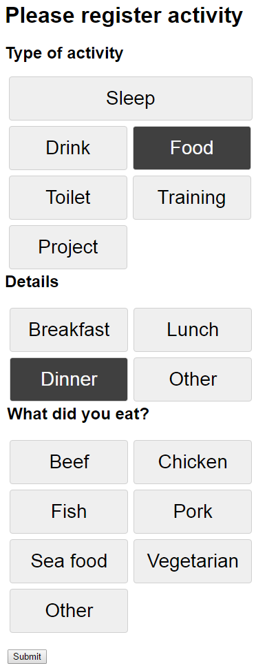
I have a list of projects I want to do and I’ve finally started to track what I am doing every day. I’ve thought of this for a while as I think it would be interesting to see if I am able to find out if there are parameters in my life that affect things like my mood and evergy level. To do this tracking I’ve made a very simple website that is hosted in Azure with an Azure SQL Database behind to store my data. This was needed to make the registration as easy as possible. I had an Excel sheet the first couple of days before I got this site up and running, and I would not recommand that approach at all if you’re going to do the same. It is a too big effort to open an excel sheet every time you drink something or whatever you want to register. So far I am very happy with how it is working out, but I have started to get quite the backlog of increasing size with ideas for improvements. I have told myself to not change anything during January and then do an evalutation of how I think it is working out and which changes are absolutely needed. I’ve also decided not too look at any of the data until January is over. I don’t want to be too aware of what I am logging in the beginning, but rather try to make logging into somethig I just do and then when I have some months of data I can see if something sticks out from them.

So far I have split registration into two parts. First part is activities during the day. Things such as what I eat, drink, if I work out and for how long etc. The other part is a registration I do at the end of each day. Here I note down my mood, energy level, stress level and overall feeling as well as some small notes about f.ex if I hang out with friends during the day or did 100 math puzzles on an app I downloaded. As mentioned I am hoping to see if there is something that affects f.ex my mood and I am able to more actively apporach these things in the future. Not really sure if this will pop up, but at least I’ll have some more data on myself and what I do during the day.

Ever done something like this or have ideas of things that are worth noting down during the day? Let me know. I know some people take these kind of things to the extreme and I probably won’t do that, but I’m always interested in new input or ideas.

Note at the end: I really like how easy it is to create a web app in Azure and everytime I now do a push to my master branch in my Git reposit the website updates within seconds. Easy to set up a Visual Studio Team Services account and create the reposit to start working right away.

Activity registration

Creating a custom map for Datazen

Datazen lets you create and use custom maps which can be a really useful feature. What I am using for creating these maps is good, old Paint, internet and QGIS, which you can download here, http://www.qgis.org/en/site/forusers/download.html.

Say you want to create a map of your office. Maybe not the most useful map, but it is a small job to create an office layout in paint so lets start there. You can use other images as your starting point, but I want to make the entire thing from scratch to show that it is possible. My office will look like the one below with eight tables that I am going to map to different persons so we can see who actually does some work around the office! (None, of the names or data is real just to be sure)

Office

Next we need to convert this .png file to a vector file. I’m using http://www.autotracer.org/ for this, but there are other methods of doing it, software, other websites etc. Upload your file and make sure to choose DXF format on your output file.

convert

Now that we have a vector file of our office lets open up QGIS and just drag the .dxf file into it. Choose the default coordinate system and the layer with geometry type “linestring”. You should now have something like this in Qgis.

qgisOutline

Right click your layer, choose “save as…” and choose ESRI shapefile in the popup. When this is done you can right click your “linestring” layer and remove it. We are now going to edit the shapefile a little to make it simpler and also give the different shapes the name of people in our office so we can map data to their names. Right click the layer and press toggle editing. You are now able to edit, merge or delete sections. We can see that our vector image has some double lines around each desk, probably because we used to thick of a brush in paint so lets remove them.

toggelEditing

Find the “Select Feature” on your toolbar and select a section of your layer. This section becomes yellow and you can delete it. After deleting some of the sections I end up with a simple layer with eight squares, my office desks.

SelectFeature

We need to give the shapes some more friendly names. Right click your layer and select “Open attribute table”. You get a popup and in my case I see that all my shapes has the name C7 in the layer column. I’m going to select a row in this attribute table, and see that by doing this the related section in my layer behind turns yellow. I now know which section I am editing and I’ll say that Joe works by this desk. Then I do the same for the rest of the sections.

Attribute

Save your layer after giving all rows a name. One more step and it is ready to be imported into Datazen. If you try to import it at this stage your data will only end up on the lines of the desk and it is REALLY hard to see what color it has. Press Vector -> Geometry tools -> Lines to polygon to make your lines into polygons, an area. You will need to create a new output shapefile and save that.

Area

Alright, time to open up Datazen. Drag a map of your choice onto the Layout View, select “custom map from file” and find your shapefile. You will need the .shp and the .dbf file. Note: You can not have the shapefile open in QGIS at this point. It’s like reading from an Excel file, you can’t have it open when adding it to Datazen.

Press preview, and voila! You have created a map and inserted it into Datazen. Have fun, now the only limit is your mind or your customers need!

OfficeDatazen